Dynamic Digital Maps - Download Links to the DDM-Template, Cookbook, Learning Documents, Selected DDMs, and Associated Geologic Exercises
Christopher D. Condit - Updated May 9, 2020
Department of Geosciences - University of Massachusetts-Amherst
National Science Foundation - Grant # DUE-CCLI-0127331 2002-2006 and NSF-EAR-0949328, 2010-2013
Space down to DDM download links and the Extended Dynamic Digital Map.
 Description of a Dynamic Digital Map
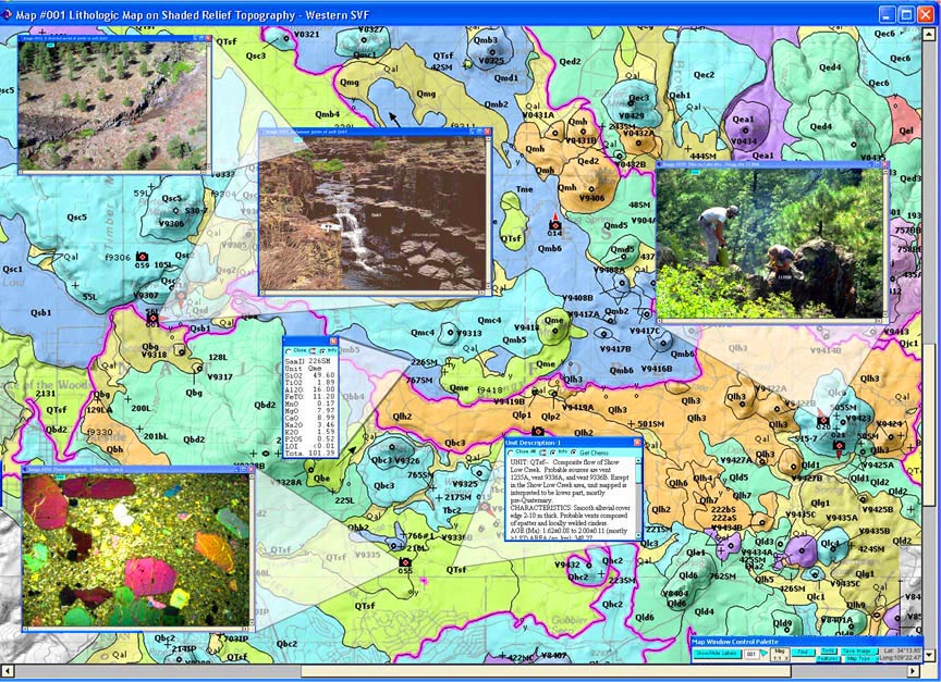
A Dynamic Digital Map is a stand-alone "presentation manager" program that displays and links maps, images, movies, data and text, like map explanations and field trip guides. A user, viewing a map in a DDM, sees a thematic map, containing camera icons and map symbols that link images, movies and text or analytical data related to those locations. DDM content, and access to it, is summarized by a searchable lists or "Indexes" of Images, Maps, and Articles opened from buttons found on the Home Screen. The Home Screen also provides an "Index Map" that graphically illustrates the coverage of maps contained in the DDM, and links to them.
Making a Dynamic Digital Map
Made using the cross-platform LiveCode programming environment, DDMs are WEB-enabled and browser independent. The "DDM-Template" is an open source program into which a LiveCode user can insert metadata (mostly file names) that enable the program to open existing maps, images, figures and movies from an organization of directories. A DDM maker modifies the Template to make their own DDM by inserting text and data directly into the program, which is then renamed to reflect its new content. The existing Template is not 64-bit compliant, and I plan to make a new Template by further updating the DDM-SVFv2-2020-05-08 and adapting the code from it to make a new 64-bit compliant Template, as was done in making the original DDM-Template (see below for downloads). For the 32-bit complaint Template, a "Cookbook" guides the LiveCode user through the steps of building the DDM. A series of short (six minute videos) and a couple of tutorials, which take a total of about eight hours, provide the background needed to use LiveCode and the Cookbook to start making a DDM. Once a Template has been completely modified, royalty-free stand-alone applications for a variety of operating systems (for example, Windows, Mac OS X, Linux) can be made directly from this single LiveCode document, regardless of the platform used to prepare the original. To download the DDM Template, Cookbook, Tutorials (Learning Documents), and DDM-File Directories (see the DDM-Making page below).
Information about, and the open-source version of LiveCode can be obtained from livecode.com .
The DDMs available on the page links below are standalone programs that run without other software; unless noted they are only 32-bit compliant.. The programs, if run locally (from web downloads, flash drives or internal hardrives) can access their data from directories within their home folder if those sub folders are also available there. The DDMs can also be used independently via web links, which require fast internet connections. In this case, they access their data [maps and images (in jpeg format), and movies (in QuickTime format)] from a file server in Chris Condit's lab at UMass-Amherst; any web server using http protocol will also work. To see any included movies on any DDM that is pre-version 2 (e.g. DDM-SVFv2-2020-05-08), Windows and Mac based computers must have the latest QuickTime Player installed (free from Apple for both platforms, at www.apple.com); Linux users should try the open-source MLPlayer to see videos. Computers with less than 1 GBB of free RAM will run these programs very slowly at best.
DDM Download Pages:
(DDM version dates here are more current than those on actual download pages, which I update less often)
-
DDM-Making
- Making a Dynamic Digital Map:
(updated 2013-05-05) includes the DDM-Template Source Code (updated 2013-08-06), DDM File Directories, Learning Documents (Tutorials), LiveCode Videos, and the DDM-Updater-2010-06-19, used to update older DDMs with minimal disruption to content or customized lay out. This version is for use with LiveCode v. 6.7.11, and will soon be replaced with that found in the DDM-SVFv2-2020-05-08 (see above listing) meant for use with LiveCode 9.5.1 and beyond.
-
EDDM-Gale-Crater
- The Extended Dynamic Digital Map of Gale Crater for Macintosh:
(content last updated 2012-10-20, with a 64-bit compliant stand-alone app EDDM-Gale-Crater2020-05-09; app and content written by Dr. Jess McBeck, 462 MB. Includes the detailed geologic map of Gale Crater by Brad Thompson (2010) among several maps, numerous HiRISE images and over 25 text files explaining the geology of the crater. See EDDM description at bottom of this page.
-
DDM-UMass
- DDM of UMass-Amherst:
(32-bit compliant) (updated 2014-06-15) Includes a 'Place Locator' with Color OrthpPhoto, Topographic and Sketch base maps and over 300 images, numerous QuickTime panoramic movies and two NASA WorldWind Movies, a search list to find buildings, parking lots, etc., and a text file describing the Department of Geosciences at UMass-Amherst.
-
DDM-MtSharpAnalogs
- DDM of Mount Sharp, Mars:
(32-bit compliant) (updated 2013-10-22) The "DDM-MtSharpAnalogs" by Lisa Korn contains two thematic maps (MOLA and Geologic), with unit explanations, of eight areas within and around Gale Crater, Mars. It also contains 33 images with captions describing each, and a thumbnail, all linked to the maps and two articles describing this research.
-
DDM-Leverett
- DDM of Leverett, Ma:
(32-bit compliant) (updated 2014-04-23) In this Dynamic Digital Map of Leverett, Massachusetts, by Alison Tenhulzen, you will find over 40 aerial photographs of Leverett, a field trip that guides the viewer to the local sites of Leverett, with both aerial and close up photographs of the sites. For the viewers interested in geology, there are two thematic maps - a surficial geologic map and a bedrock geologic map - that display the local geology, as well as a cross section of the Ryans Hill area. The DDM is a work in progress, missing photos from the Ryans Hill Field Trip can be found in the DDM-NE, and will be included in in future updates of this DDM.
-
DDM-OctMtnTrails
- DDM-OctMtnTrails, Ma:
(32-bit compliant) (updated 2014-06-12) In this Dynamic Digital Map of the Trails of October Mountain State Park, Massachusetts, by Mark Millett, you will find over 38 photographs of the park�s trails, a field trip that guides the viewer to the local sites of around the park, and two other articles, one that give a brief the history of the park and another about the DDM itself. There are three thematic maps - a color orthophoto map, a topographic map and a shaded relief map, each incorporating the area's mountain bike trails, which are color coded according to difficulty. An animation allows you to follow a marker that moves along a chosen track.
-
DDM-TSP
- DDM of the Tatara-San Pedro Volcanic Complex:
(32-bit compliant) (updated 2009-04-17) The Tatara-San Pedro Volcanic Complex is a less than one million year old Andean arc volcano in east-central Chile. The DDM displays four thematic maps, 263 images and sample locations plotted on those images for most of the paleomagnetic and geochemical sites. A multi-field season effort spearheaded by Mike Dungan resulted in what is arguably the best geologically characterized Andean arc volcano; this DDM displays the initial results of that work.
-
DDM-Patagonia
- DDM of the Patagonia:
(32-bit compliant) (updated 2008-03-11) This study by Laurie Brown and colleagues displays the location and data of over 130 paleomagnetic sites in southern Patagonia (Argentina) collected over the last few years. Eight map segments, made from NASA World Wind satellite images program are available as a starting point. Each site is plotted on a map segment, which is linked to a listing of paleomagnetic results, when available, along with any existing geochronologic data. Also connected are almost 300 geologic and site photographs, along with 11 QuickTime movies and 360 degree panos.
-
DDM-Souhegan
- DDM of the Souhegan River:
(32-bit compliant) (updated 2008-03-26) This study by Joe Rogers of the Northeastern Instream Habitat Program involved intensive habitat mapping at eleven sites over three flow levels, as well as fish sampling at those locations. Data on temperature, flow, bank and bed characteristics, macro-invertebrates, mussels, along with extensive photo documentation and other data are combined in the interactive DDM.
-
DDM-KVNP
- Dynamic Digital Map of Kilauea Crater:
(32-bit compliant) (updated 2009-06-15) This program presents two thematic maps of the Kilauea Crater and Volcanoes National Park in Hawaii. The DDM was compiled by Christine Nygren. It contains a field trip guide for the Crater Rim Drive tour along Crater Rim Road encompassing the crater, with links to more than 50 photos, most by Steve Young, and one movie. Together, these features give the user a unique perspective with which to view this beautiful area of the world.
-
DDM-CR
- The Dynamic Digital Map of Costa Rica by Suzanne Fleury (32-bit compliant) (updated 2008-12-20) resulted from a field trip taken by a course entitled "The Geology of Costa Rica", offered through Castleton State College in Castleton, Vermont in the summer of 2007. This DDM, however is not geology specific. It is aimed at the full experience from the trip. Through this map the user can explore the four most active volcanoes in Costa Rica, see the sights in the tropical Cloud Forest, learn about the geology of certain areas, take in the beauty of Fortuna Falls, and even see the monkeys bounce through the trees in Manuel Antonio National Park on the coast.
-
DDM-CBOrchs
-The Dynamic Digital Map (DDM) of Clark Brothers Orchards (32-bit compliant) (updated 2008-12-19) by Heather Clark is an interactive map of the Clark Brothers Orchards, located in the Apple Valley section of Ashfield, Massachusetts. A fifth-generation family farm, it is located in a setting both pleasing to the eye and spirit and uniquely well suited to growing apples. The DDM includes a topographic and orthophoto map of the farm, with camera icons for more than 100 pictures (many of them aerial obliques), and two QuickTime panoramic movies, one made with from NASA World Wind and one made with 3-D topographic maps from Mass GIS. Several articles tell different aspects of the history of the farm and the Clark family, and there is an article with some general information about apples and links to related websites.
-
DDM-Knightville
-The Dynamic Digital Map of the Littleville and Knightville Dams by Mike Sacchetti (32-bit compliant) (updated 2008-12-17) depicts the recreation areas of these dams, which are located west of the Connecticut River: the Knightville, on the East branch of the Westfield River, and the Littleville on the Middle Branch. This DDM will allow you to explore these functional landscapes and get a up close view of what the dams really look like and how they work.
-
DDM-RFrostTrail
- DDM of the Robert Frost Trail:
(updated 2009-06-04) This study by Christine Harrington displays maps and images of a 12 mile segment of the 47 mile-long Robert Frost trail, beginning at "The Notch" and ending in Amherst Woods, to the north and east. The trail is shown in four map segments as either a topographic or an orthophoto map. Camera icons, placed on the map showing the direction they were taken, link to one of 114 images included in the interactive DDM.
-
DDM- HolyokeHike
- DDM of Hiking the Holyoke Range:
(32-bit compliant) (updated 2009-04-13) This program, by Ben Clinton, combines a virtual hiking trip with a detailed map of biking trails, including ratings and a brief description of each trail. Hiking the Holyoke Range provides the user with the opportunity to pre- or post-view a trip along this seven mile path in Western Massachusetts. The main trail straddles the spine of the only mountain range that crosses the Connecticut Valley from east to west. Included are numerous photos, videos, and three thematic map bases, one of topography, and another of the another of orthophotos. The final map by Eric Barnes, an OPRA Hampshire College alumni, overlays numerous hiking/biking trails on a topo map, and includes labels with linked trail descriptions and ratings (the trails . Two NASA World wind satellite 3D rotational QuickTime movies round out the project.
-
DDM-Mars
- DDM of Mars:
(15 August 2005 version updated on 2007-12-05 for Vista & Mac Universal binaries) Created by Selby Cull, Dynamic Digital Mars includes a wealth of maps, images, and articles and exercises that involve searching for mineral deposits and designing a mission to Mars. A captivating introduction to the geology of Mars.
-
DDM-Marl
- DDM of Marlborough Quadrangle, MA:
(32-bit compliant) (updated 2005-10-13) The "DDM-Marl" is a 'proof-of-concept' draft that contains three thematic maps (bedrock, surficial and surficial material, with simplified and detailed unit explanations), a cross section (for the bedrock map), two correlation charts (for the bedrock and surficial maps) and three articles, one describing each map type.
-
DDM-Davis Mine
- DDM of the Davis Mine: This DDM (dated 2004-06-14), a part of a master's thesis by Jessica Bloom, provides a visual tour of an acid mine drainage and its subsequent natural attenuation, and a guide to the location of each streamwater sampling site and to multi-level wells. The DDM contains 69 images and three QuickTime VR panoramic movies, each with a figure caption, and a topographic map of the area, divided into three detailed maps.
-
DDM-Holtwood
- DDM of Holtwood Pa: (32-bit compliant) Dated 2004-05-27, it includes two detailed airphoto map bases showing spectacular outcrops of brittle fractures which are present in southeastern Pennsylvania, just below the Holtwood Dam on the floor of the Susquehanna River, along with 32 linked photos of the outcrops, by Kendra Clark.
-
DDM-Moon
- DDM of Moon:
updated 2005-03-25, is a graphical atlas that provides access to over 550 maps in three thematic variations, and images and movies, including the ability to find most named lunar features. The program displays simultaneously up to nine images and one map mosaic at resolutions from 1/64 to 1/2 degree per pixel. A Macintosh classic version, built in SuperCard, also includes an automated tour of the program.
-
DDM-SVF-SC
Downloads of the Original Springerville Volcanic Field in Arizona published on CD by the Geological Society of America in 1995 (last updated on 7 March 2004, Mac Classic only, made with SuperCard).
Selected Refereed References
Condit, C.D., 2010, Dynamic Digital Map of the Springerville Volcanic Field and the DDM-Template: An example of an open-source tool to distribute maps, data, articles, and multi-media materials, Geosphere; August 2010; v. 6; no. 4; p. 1�13; doi: 10.1130/GES00531.1; 9 figures. download pdf file (7 MB).
Condit, C.D., 2005, Dynamic Digital Maps: A Means to Distribute Maps and Associated Media via Web and CD, in D.R. Soller, ed., Digital Mapping Techniques '05 -- Workshop Proceedings: U.S. Geological Survey Open-file Report 2005-1428, 16 pages. download pdf file (2.7 MB).
Boundy, T.M and Condit, C.D., 2004, Bringing The Field Into The Classroom By Using Dynamic Digital Maps To Engage Undergraduate Students In Petrology Research, J. Geologic Education, v. 52, no. 4, p. 313-319 (open September issue cover)
Condit, C.D., 2000, Dynamic Digital Maps - A Macintosh CD-ROM, Univ. Massachusetts Dept. Geosciences Contribution No. 72, 550 MB CD-ROM, pamphlet, 46p.
Condit, C.D., 1999, Components of Dynamic Digital Maps, Computers & Geosciences, v. 25, p. 511-522.
Condit, C.D., 1995a, Dynamic Digital Map: The Springerville Volcanic Field: Prototype color digital maps with ancillary data. Boulder Colorado, Geol. Soc. Am. Digital Pub. Series DPSM01MC (CD-ROM for the Macintosh); v. 4.10.95 size: 36.7 megabytes.
Condit, C.D., 1995b, DDM.SVF: A prototype Dynamic Digital Map of the Springerville volcanic field, Arizona, GSA Today, v.5, p. 69, 87-88.
Condit, C.D., 1999, Presentation of Volcanological and Planetary Datasets Using Dynamic Digital Maps, Geol. Soc. Am. Abst. with Prog., Vol. 31, No. 7, October 1999.
Selected Presentations & Abstracts
Condit, C.D., 2001, Using Dynamic Digital Maps Interactively in Large Geology Courses, Geol. Soc. Am. Abst. with Prog., v. 33, no. 6.
Condit, C.D., and Boundy, T.M, 2002, Bringing the field into the classroom: using Dynamic Digital Maps to engage undergraduate students in petrology research, Geol. Soc. Am. Abst. with Prog., v. 34, No. 6, p. 454.
Condit, C.D., Williams, Wendi J.W., 2003, Using Dynamic Digital Mapping with universal design goals to provide enriched learning opportunities to students and faculty, GSA Abstracts with Programs Vol. 35, No. 6.
Condit, C.D., 2005, Dynamic Digital Maps: the DDM-Template and Cookbook, a Powerpoint presentation made at the USGS-Assoc. Am. State Geologist's April 2005 Digital Mapping Techniques Conference, Baton Rouge La, Selected Presentations, 19.5 MB.
Bug reports and suggestions to ccondit@geo.umass.edu
Updated May 9, 2020
Go to DDM Homepage
Go to Chris Condit's UMass Home Page
Go to UMass Geoscience Faculty Index
The Extended Dynamic Digital Map
The summer of 2012, then grad student Jess McBeck, using the LiveCode programming environment, built a streamlined version of the Dynamic Digital Map app and demonstrated this using the geologic map of Gale Crater, Mars for its content. Although this app shares much of the basic functionality of the Dynamic Digital Map app, it differs markedly in its size, organization and architecture, and so we gave it a new name: The Extended Dynamic Digital Map (EDDM).
EDDMs are perhaps best described as a sort of computerized, self-authored, interactive textbook. This software enables people to easily gather and present data so that users of the EDDM may actively absorb whatever material the designer of the EDDM decides to include. For example, we designed the EDDM of Gale Crater to teach people about the geology of Gale Crater, which is currently the home of the NASA Mars Rover - Curiosity.
The EDDM-Gale Crater for MacIntosh (462 MB, content last updated by Jess McBeck 2012-10-20, with a 64-bit compliant app made of it 2020-05-09) can be download from DDM-EDDM-Gale-Crater; a poster on it was shown at the American Geophysical Union at the V018 session of December 2012 AGU meeting in San Francisco (McBeck and Condit, 2012), and it was introduced at the Pardee Digital Mapping Session at the GSA National meeting in Charlotte Nov. 5, 2012. Jess has moved on to other efforts after finishing her doctorate at UMass, so although parts of the EDDM have been incorporated into the new 64-bit compliant DDM, further development of the EDDM per-se is not anticipated. I made a stand-alone of the EDDM of Gale Crater on May 9, 2020 (EDDM-Gale-Crater-2020-05-09) which appears to be functional, and is included in the downloads at the above URL.
