 Links to download the latest cross-platform, web enabled versions of the Dynamic Digital Map of Selected Sedimentary Rock Outcrops in Western Massachusetts (DDM-SedRxWMa) are found below.
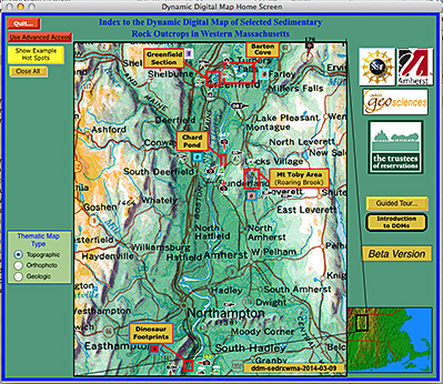
The Dynamic Digital Map of Sedimentary Rocks in Western Massachusetts examines the sedimentary rocks of five areas in the Deerfield Basin, each of which either typify the location, or display exceptional features. These rocks reveil a rich geologic story that encompasses both the late Triassic - early Jurassic and the late Pleistocene periods. The sedimentary structures at these localities in turn lend themselves to interpreting the regional geology of the area. Illustrating this are about 184 images, ~18 QuickTime movies and 6 animations, which are linked to the maps and guide articles of the DDM. Many of the images are oblique aerial photos taken by Chris Condit, used to show the geology in its scenic setting.
This Dynamic Digital Map presents three thematic maps of five areas, visited by students in the Fall 2006 Sedimentology class at the University of Massachusetts, Department of Geosciences. The maps and media were initially developed by the class, and, with additional work extending into 2009, they were complied into the DDM by Chris Condit and Steve Nathan, after content review by John Hubert.
The maps, in stratigraphic succession include:
(1). Roaring Brook, Leverett/Sunderland, MA - The Mount Toby Conglomerate (examines the Mt. Toby alluvial fan);
(2). Chard Pond, Sunderland, MA - The Turners Falls Formation and the Mount Toby Conglomerate (examines the sedimentary structures seen at the contact of the two formations);
(3). Barton Cove, Gill, MA - The Turners Falls Formation (examines tectonic features located mid-section in the formation);
(4). Greenfield Stop and Shop, Greenfield, MA - Sugarloaf Arkose, Fall River Beds, and Deerfield Basalt (examines the fluvial features within the Arkose at the base of the outcrop as well as the two contacts between the three units further up section); and
(5). Dinosaur Footprints, Holyoke, MA - The Jurassic Portland Formation (examines the dinosaur footprints as well as sedimentary structures within the arkosic ~200 Ma old siltstone).