A Dynamic Digital Map of October Mountain State Forest Trails, Massachusetts
Department of Geosciences
University of Massachusetts-Amherst
By Mark Millett
Updated 9 to run on Mac OS 10.9 (Mavrick) and Windows 7 & 8
Links to download
the latest cross-platform, web-enabled versions of the Dynamic Digital Map of the Trails of October Mountain State Forest are found below.
Welcome to the latest version of the Dynamic Digital Map of the Trails of October Mountain State Forest, Massachusetts (DDM-OctMtnTrails). In this DDM 37 photographs of the trails of October Mountain State Forest are linked to maps of the area. 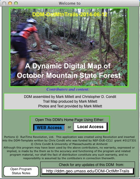 There is also a hyperlinked field trip that guides the viewer to several local sites of and around October Mountain State Forest. Topics of two other articles give a brief history of the park and an introduction to the DDM-OctMtnTrails. The four thematic maps include an orthophoto, a topographic, a shaded relief map, and a composite Orthophoto map with Shaded Relief and Topography, each incorporating the area's mountain bike trails, which are color coded according to difficulty. An animation allows you to follow a marker that moves along a chosen track.
At 16,500 acres, October Mountain is the largest state forest in Massachusetts, offering 47 campsites which dot a sunny hillside and offer a great base to explore this vast forest. Trails are available for every level of experience, and include the famous Appalachian Trail. One of the most scenic trails leads through Schermerhorn Gorge, a striking natural feature that has intrigued generations of geologists. Countless varieties of wild plants and animals can be found throughout the varied terrain of this vast forest. The name of "October Mountain" is attributed to writer Herman Melville, who enjoyed viewing the mountain from his home in Pittsfield.
The downloads below are standalone programs that run without other software. Unzip the compressed file sent, open the resulting folder, and start the program from within the folder. From the start up screen, use the yellow "WEB Access" button. Because the programs access their data (maps, images, figures, and movies) from a file server at UMass, and because they are using the web, they require a fast internet connection to run. All DDMs can alternatively access data from a CD, DVD or hard drives, if the data are available in those locations. To view any included movies, both Windows and Mac computers must have the latest QuickTime Player installed (free from Apple for both platforms, at www.apple.com). Please be sure Windows computers have their latest video drivers installed! Computers with less than 1 GB of free RAM will run these programs very slowly at best. To use the DDM via WEB access, having speeds/band provided by DSL connections are a bare minimum for comfortable use.
-
DDM-OctMtnTrails-2014-06-19.exe- A Windows version (Win98, 2000, XP, Vista, 7, and 8) sent in a folder (DDM-OctMtnTrails-Windows) as a Zip archive
DDM-OctMtnTrails-Windows.zip
(~7.2 MB uncompressed)
-
DDM-OctMtnTrails-2014-06-19.app - A Macintosh OSX Universal Version, sent in a folder (DDM-OctMtnTrailsMacOSX) as a Zip file
DDM-OctMtnTrails-MacOSX.zip
(~16.9 MB uncompressed)
-
DDM-OctMtnTrails-2014-06-19 A Linux Version, sent in a folder (DDM-OctMtnTrails-Linux) as a zip file
DDM-OctMtnTrails-Linux.zip
(~7.2 MB uncompressed)
Please send bug reports and comments to Mark mmillett@student.umass.edu or Chris Condit ccondit@geo.umass.edu
Updated June 19, 2014
Go to DDM Homepage
Go to UMass Geoscience Faculty Index