Downloads of the Dynamic Digital Map
of the Springerville Volcanic Field (DDM-SVF) Cross-Platform Stand-Alone Programs Made with LiveCode
Christopher D. Condit - Department of Geosciences
University of Massachusetts-Amherst
National Science Foundation - Grants NSF-DUE-CCLI-0127331 2002-2006 and NSF-EAR-0949328, 2010-2013
Go here to the 2019 DDM-SVFv2 Homepage
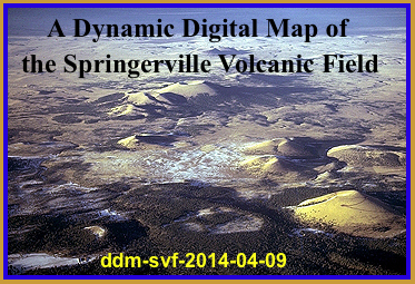
Welcome to the location with links to download the latest cross-platform, web enabled versions of the Dynamic Digital Map of the Springerville Volcanic Field (DDM-SVF). The Springerville is a late Pliocene to Holocene basaltic volcanic field located in east-central Arizona. It is dominated by over 400 mapped cinder cones and associated lava flows. The DDM displays nine thematic geologic maps of the field, 234 images and QuickTime movies (many aerial and from NASA's World Wind satellite), over 577 major and trace element whole-rock chemical analyses, mineral chemistry for 31 units, paleomagnetic polarity data from >180 sites, ~ 40 K-Ar dates, and Sr, Nd and Pb istopic analyses, all linked to sample sites located on the maps and in some of the photos. The DDM also includes three articles, each with numerous hyperlinks to the maps and images. The first is an introduction to the geology of the field, and to the map and mapping conventions. The other two are field trip guides. The first of the guides is a modified version of the 1989 IAVCEI field trip which concentrates on the petrology of the field; it contains hyperlinks to icons of field trip stops, displayed on the lithologic map. The second guide concentrates more on the volcanologic and tectonic features of the field.
A Guided Tour button on the lower right side of the Home Screen will give you an automated tour of the program, in the form of a nine-minute scripted playback, introducing you to the basics of how to use a DDM.
Go here to see what DDMs are and how you can make them.
These downloads are standalone programs that run without other software. The programs access their
data [maps and images (in jpeg format), and movies] from my file server using the web, thus requiring fast internet connections. All DDMs can access data from CDs or Hard Drives, if the data is available in those locations. To see any included movies, both Windows and Mac based computers must have the latest QuickTime Player installed (free from Apple for both platforms, at www.apple.com). Computers with less than one GB of free RAM will run these programs very slowly at best. Downloads labeled "Opens using Web-Access with Automatic Start to Tour" can be reset to open without Autostart to Tour (see the ReadMe file in downloaded folder).
-
ddm-svf-2014-04-09.exe- A Windows version (Win98, 2000, XP, Vista, Windows 7) sent as a Zip archive
ddm-svf-win.zip
(both this and the tour below ~18 MB compressed, ~37 MB uncompressed)
ddm-svf-win-web-tour.zip
(Opens using Web-Access with Automatic Start to Tour)
-
ddm-svf-2014-04-09.app - A Macintosh OSX Universal Application, sent as an Zip archive
ddm-svf-mac.zip
(both this and the tour below ~20 MB compressed, ~41 MB uncompressed)
ddm-svf-mac-web-tour.zip
(Opens using Web-Access with Automatic Start to Tour)
-
ddm-svf-2014-04-09- A Linux version, sent as a zip file
ddm-svf-linux.zip
(both this and the tour below ~19 MB compressed, ~39 MB uncompressed)
ddm-svf-Mac-Classic
(8.2 MB compressed, 23.2 MB uncompressed)
-
ddm-svf-2014-04-09.livecode - The LiveCode-Open-Source code sent as a zipped file
DDM-SVF-Cross-Platform
(~16 MB as sent, ~49 MB when uncompressed)
-
DDM.SVF.v.2002.01.07- The Mac-Classic-only stand alone built using SuperCard sent as a self-extracting BinHexed (hqx) file (an update of the original DDM published on CD by the Geological Society of America, 1995)
DDM-SVF-Mac Classic only
(24.2 MB as sent, 40.4 MB when unBinHexed)
Bug reports and suggestions to ccondit@geo.umass.edu
Updated January 24 2019
Go to DDM Homepage
Go to UMass Geoscience Faculty Index
Go to Chris Condit's UMass Home Page